RADAR
The electronics principle on which a radar system operates is very similar to the principle of sound-wave reflection. If you shout in the direction of a sound-reflecting object (like a rocky canyon or cave), you will hear an echo.
If you know the speed of sound in air, you can then estimate the distance and general direction of the object. The time required for a return echo can be roughly converted to distance if the speed of sound is known. This complex system uses electro-magnetic energy pulses in much the same way, as shown in the first illustration below.
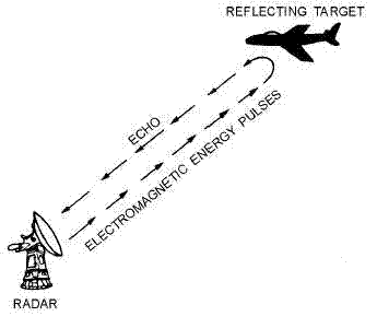
RADAR echo.
The radio-frequency (rf) energy is transmitted to and reflects from the reflecting object. A small portion of the energy is reflected and returns to the set. This returned energy is called an ECHO, just as it is in sound terminology. Sets use the echo to determine the direction and distance of the reflecting object.
NOTE: The terms TARGET, RETURN, ECHO, CONTACT, OBJECT, and REFLECTING OBJECT are used interchangeably throughout this and subsequent tutorials to indicate a surface or airborne object that has been detected by the system.
These systems also have some characteristics in common with telescopes. Both provide only a limited field of view and require reference coordinate systems to define the positions of detected objects.
If you describe the location of an object as you see it through a telescope, you will most likely refer to prominent features of the landscape. This system requires a more precise reference.
The surface angular measurements are normally made in a clockwise direction from TRUE NORTH, as shown in the next illustration below, or from the heading line of a ship or aircraft.
The surface of the earth is represented by an imaginary flat plane, tangent (or parallel) to the earth’s surface at that location. This plane is referred to as the HORIZONTAL PLANE. All angles in the up direction are measured in a second imaginary plane that is perpendicular to the horizontal plane.
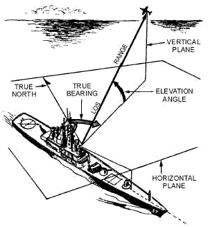
RADAR reference coordinates.
This second plane is called the VERTICAL PLANE. The radar location is the center of this coordinate system. The line from the set directly to the object is referred to as the LINE OF SIGHT (los). The length of this line is called RANGE. The angle between the horizontal plane and the los is the ELEVATION ANGLE. The angle measured clockwise from true north in the horizontal plane is called the TRUE BEARING or AZIMUTH angle. These three coordinates of range, bearing, and elevation describe the location of an object with respect to the antenna.
Measurement of range, or distance...
Minimum range, maximum range, and ambiguous returns
PRF: Pulse repetition frequency and power calculations
Antenna Height, Speed, and Bearing
Altitude, target, range, and bearing resolution
Accuracy, pulse shape, and atmospheric conditions
Principles of Operation
Scanning: Stationary-Lobe, Methods of Beam scanning, and Mechanical scanning
Electronic Scanning
Transmission-methods: continouos-wave, the Doppler affect, and uses of the CW Doppler system
Frequency-modulation-method, pulse-modulation, and pulse-doppler method.
Classification and Use: Military classification, function and type, and search RADAR
Air-Search and Height-Finding
Tracking, Missile-guidance, CCA, GCA, and Airborne systems


Download the NEETS for your own library.

If you would like to download a module or the entire set, we just require a small fee to ensure your manuals are virus free from our secure server. Just click on the highlighted NEETS link.
Become a loyal member to our site. It's free!
Site Search

Tweet


Translate your page
If English is not your first language you can Translate the text on this page to any one of the languages found in the drop down menu. Select your language from the list for an instant translation.
Looking for something unique for your project? Just enter a keyword into the box to search for your item on Amazon
Related Pages

Docircuits interactive circuit simulator

Become an Electronics Technician

Convert most anything with this utility

